Radiation Levels Will Concentrate in Pockets In Baja California and Other West Coast Locations
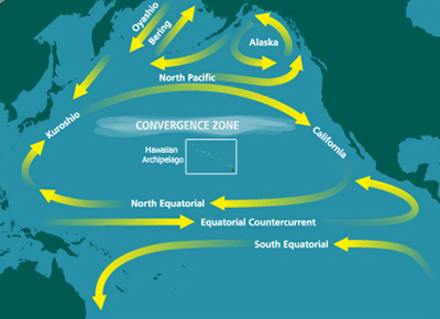
An ocean current called the North Pacific Gyre is bringing Japanese radiation to the West Coast of North America:

While many people assume that the ocean will dilute the Fukushima radiation, a previously-secret 1955 U.S. government report concluded that the ocean may not adequately dilute radiation from nuclear accidents, and there could be “pockets” and “streams” of highly-concentrated radiation.
The University of Hawaii’s International Pacific Research Center created a graphic showing the projected dispersion of debris from Japan:
Last year, scientists from the National Oceanic and Atmospheric Administration’s (NOAA) Pacific Marine Environmental Laboratory and 3 scientists from the GEOMAR Research Center for Marine Geosciences showed that radiation on the West Coast of North America could end up being 10 times higher than in Japan:
p>
After 10 years the concentrations become nearly homogeneous over the whole Pacific, with higher values in the east, extending along the North American coast with a maximum (~1 × 10⁻⁴) off Baja California.
***
With caution given to the various idealizations (unknown actual oceanic state during release, unknown release area, no biological effects included, see section 3.4), the following conclusions may be drawn. (i) Dilution due to swift horizontal and vertical dispersion in the vicinity of the energetic Kuroshio regime leads to a rapid decrease of radioactivity levels during the first 2 years, with a decline of near-surface peak concentrations to values around 10 Bq m−3 (based on a total input of 10 PBq). The strong lateral dispersion, related to the vigorous eddy fields in the mid-latitude western Pacific, appears significantly under-estimated in the non-eddying (0.5°) model version. (ii) The subsequent pace of dilution is strongly reduced, owing to the eastward advection of the main tracer cloud towards the much less energetic areas of the central and eastern North Pacific. (iii) The magnitude of additional peak radioactivity should drop to values comparable to the pre-Fukushima levels after 6–9 years (i.e. total peak concentrations would then have declined below twice pre-Fukushima levels). (iv) By then the tracer cloud will span almost the entire North Pacific, with peak concentrations off the North American coast an order-of-magnitude higher than in the western Pacific.
***

(“Order-of-magnitude” is a scientific term which means 10 times higher. The “Western Pacific” means Japan’s East Coast.)
In May, a team of scientists from Spain, Australia and France concluded that the radioactive cesium would look more like this:

And a team of top Chinese scientists has just published a study in the Science China Earth Sciences journal showing that Fukushima nuclear pollution is becoming more concentrated as it approaches the West Coast of the United States, that the plume crosses the ocean in a nearly straight line toward North America, and that it appears to stay together with little dispersion:
p>On March 30, 2011, the Japan Central News Agency reported the monitored radioactive pollutions that were 4000 times higher than the standard level. Whether or not these nuclear pollutants will be transported to the Pacific-neighboring countries through oceanic circulations becomes a world-wide concern.
***
The time scale of the nuclear pollutants reaching the west coast of America is 3.2 years if it is estimated using the surface drifting buoys and 3.9 years if it is estimated using the nuclear pollutant particulate tracers.
***

p>The half life of cesium-137 is so long that it produces more damage to human. Figure 4 gives the examples of the distribution of the impact strength of Cesium-137 at year 1.5 (panel (a)), year 3.5 (panel (b)), and year 4 (panel (c)).
***
It is worth noting that due to the current near the shore cannot be well reconstructed by the global ocean reanalysis, some nuclear pollutant particulate tracers may come to rest in near shore area, which may result in additional uncertainty in the estimation of the impact strength.
***
Since the major transport mechanism of nuclear pollutants for the west coast of America is the Kuroshio-extension currents, after four years, the impact strength of Cesium-137 in the west coast area of America is as high as 4%.


